|
|

|
No. 83 August 2012 |
| |
Geoscience
Warning: Third Pole Facing Glaciers Melting
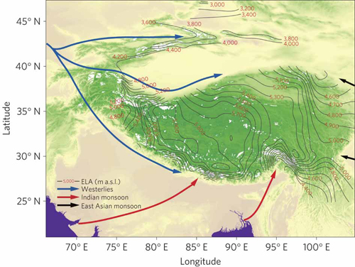
As the water tower in Asia, glaciers on the Tibetan Plateau and its surrounding regions hold the largest ice mass outside the Arctic and Antarctic regions, and closely concern livelihood in the region under global warming. The status of glaciers in the region has become a research focus recently, attracting studies using various approaches, which made the controversies even foggier. For a more comprehensive scientific research and better understanding of the glacial status in the region, Yao Tandong and his group integrated their in-situ measurements with other glacier observation data, topographic maps and satellite images from LANDSAT-MSS/TM/ETM+, ASTER and LISS. They comprehensively assessed the areal variation of 7060 glaciers on the Tibetan Plateau and its surroundings in the past 30 years, focusing on glaciers at length variation of 82 and mass balance of 15 glaciers throughout the region. Their study finds ��systematic differences in glacier status from region to region, with the most intensive shrinkage in the Himalayas (excluding the Karakorum) characterized by the greatest reduction in glacial length and area and the most negative mass balance. The shrinkage generally decreases from the Himalayas to the continental interior and is the least in the eastern Pamir, characterized by the least glacial retreat, area reduction and positive mass balance.�� Yao Tandong and his group attributed the systematic differences to the dominance of the two major atmospheric circulation systems, i.e., the westerlies and the summer monsoon. The intensifying westerlies contribute to increasing precipitation in the Pamir region, while otherwise in the Himalayas with the weakening summer monsoon. The study recently published in Nature Climate Change. A news feature by Jane Qiu was also dedicated to the study on Nature��s website.
Updated View on Aridification in Central Asia
A collaborative study on central Asia climate was led by scientists from the Cold and Arid Regions Environmental and Engineering Institute, CAS jointly with other scientific units. This study investigated the factors driving the aridification in central Asia in mid-late Miocene: the global cooling or the uplift of the Tibetan Plateau? The researchers examined and summarized multiple climatic indexes available from the continental Eurasia, which are covering the period between 17 Ma and 5 Ma. Research results reveal that the global cooling was the major mechanism causing the mid-late Miocene aridification in central Asia; whereas the rain shadow effects were dominant in northwestern and northeastern Tibetan Plateau. Future work will focus on the quality and reliability of climatic indexes, especially in Inner Asia, to better understand the mechanisms of aridification. This study has been published on Earth Science Reviews (Miao Yunfa, Herrmann Mark, Wu Fuli, Yan Xiaoli, Yang Shengli, 2012. 112, 155�C172).
IPOFlux Data Released Free
The high-precision air-sea heat flux data sets��named as IPOFlux��over Indian-Pacific Ocean were obtained and released free of charge by a research team headed by Prof. Chen Yannian from the Institute of Oceanology, CAS. Such datasets concerned with the heat exchange process and variation of the air-sea interface were successfully obtained through COARE3.0 bulk flux algorithm and neural network method based on the SSM/I and AVHRR satellite data. In the meantime, the linkage between the observation data from the National Data Buoy Center (NDBC) and Tropical Atmosphere Ocean Project (TAO) and the data from SST is built by the researchers, and then the near sea surface temperature and relative humidity are retrieved using the neural network model, which is established in accordance with the data of wind speed, precipitation rate, columnar cloud liquid water and columnar water vapor from the satellite remote sensing data (AVHRR&SSM/I). The temporal coverage of such datasets is from January 1988 to December 2009 with spatial resolution of 0.5���0.5��.
copyright © 1998-2015
CAS Newsletter Editorial Board: 52, Sanlihe Road, Beijing 100864,
CHINA
Email: slmi@cashq.ac.cn