

A mountain in the Himalayas in Nepal (Image by skeeze from pixabay)
The geologic structures in the Tethyan orogenic belt are complex; they have been subjected to several devastating earthquakes, plate collisions, and subduction-associated orogenic zones. Many features related to the Eurasian lithosphere and the subduction of the Indian and Arabian Plates remain controversial. More accurate seismic velocity and anisotropy structural models are needed to better understand the dynamic mechanisms involved in continent–continent collisions.
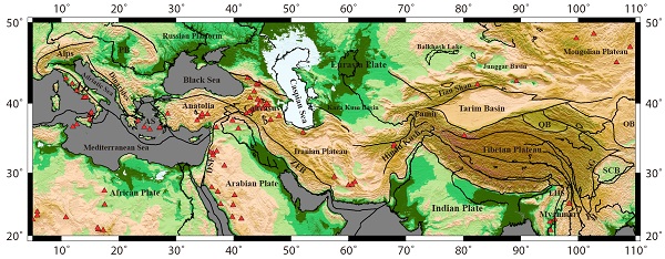
Seismic tomography is an important tool for imaging the structure of the earth. The rapid development of global seismic stations enables the acquisition of more accurate imaging results and provides a higher-resolution database. However, the conventional Pn tomography methods do not completely eliminate the systematic errors owing to the Moho depth variations. Prof. Lyu Yan and partners proposed a modified Pn velocity and anisotropy tomography method by considering depth variations of the Moho, and obtained more accurate uppermost mantle Pn velocity and anisotropy structure beneath the Tethyan orogenic belt. This work was published in Journal of Geophysical Research: Solid Earth.
The more accurate Pn imaging indicates that 1) the Adriatic microplate dives to the east and west, 2) the hot material upwelling caused by subduction beneath the Tibetan Plateau is not as significant as that in the Caucasus and Myanmar regions, 3) the lithosphere has a coupled rotation movement around the Eastern Himalayan Syntaxes, and 4) the areas north and south of 26°N in the Yunnan region are affected by different geodynamic processes. High Pn velocities indicate that the structures are stable and that their lithospheric temperatures are low, whereas low Pn velocities indicate that either the temperatures in the uppermost mantel are high or the uppermost mantle has been chemically modified. The new uppermost mantle velocity and anisotropy structures beneath the Tethyan orogenic belt provide additional information concerning continental collision processing and its associated dynamic mechanisms.
The work was supported by the Strategic Priority Research Program (B) of the Chinese Academy of Sciences and the National Natural Science Foundation of China.

Figure: Simplified tectonic map of the study area. (Image by Prof. Lyu Yan )
For more information, please contact:
Prof. Lyu Yan
Division: Earth's Deep Structure and Process
Group: Structure of Earth's Deep Interior
Institute of Geology and Geophysics
E-mail: lvyan@mail.iggcas.ac.cn